A Community Conservation Proposal
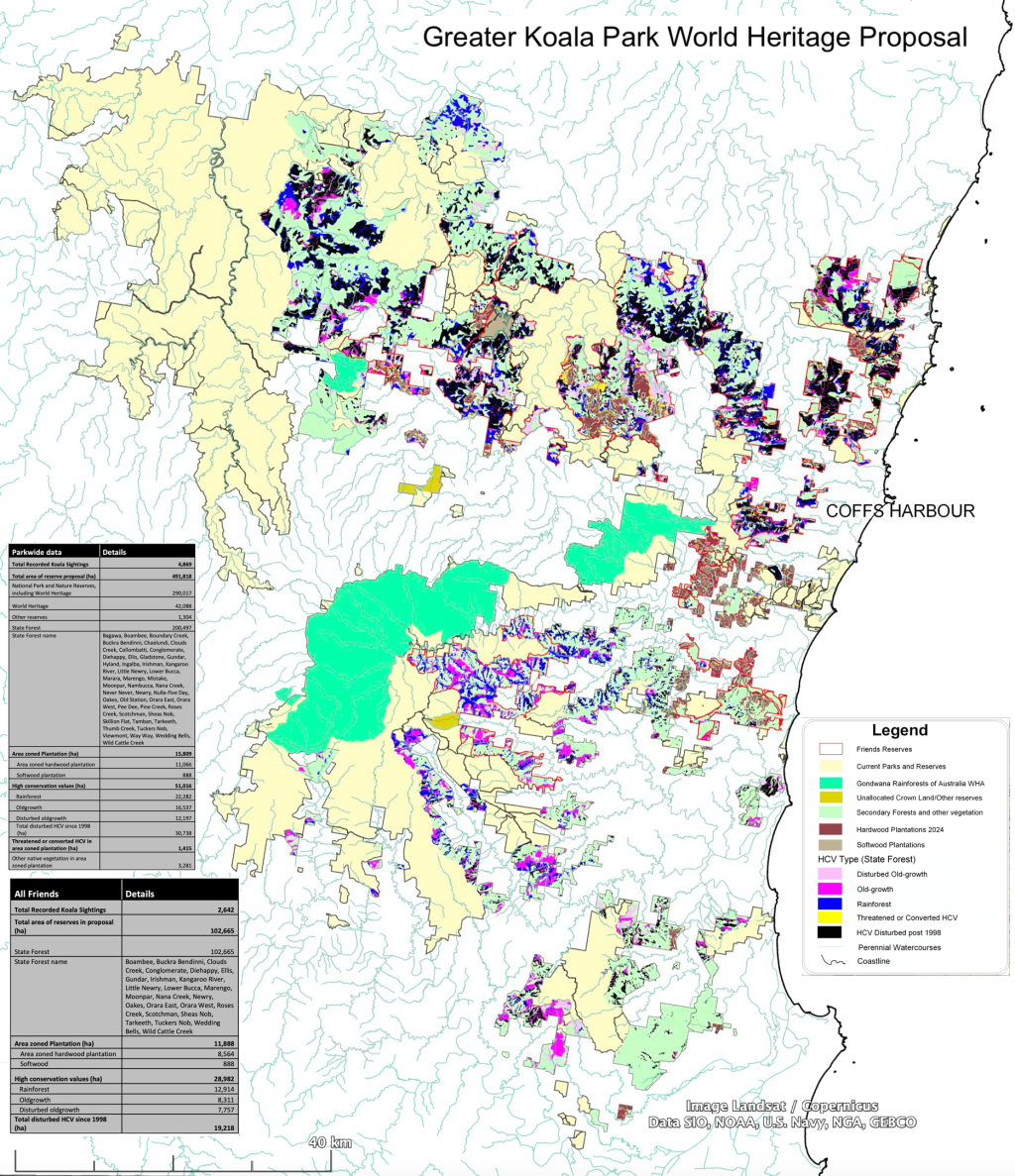
1) High conservation values
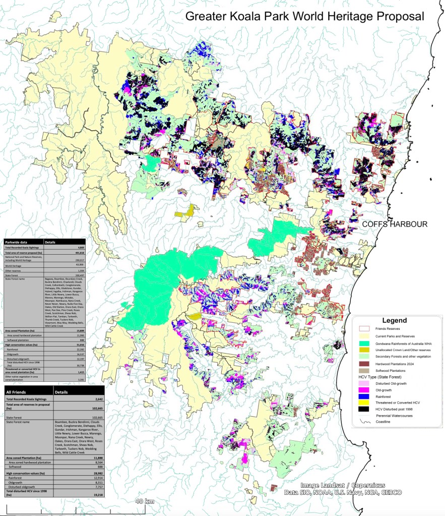
This map contains validated Commonwealth and State data, from the Regional Forest Agreement process, identifying the high conservation value forest (old-growth, disturbed old-growth, and rainforest), areas of which have been disturbed (logged) since 1998, as well as the secondary forest, and hardwood plantations. It can be clearly seen that some of the conservation values present outside the plantations, also exist within them, and that some of these remain, have already been disturbed, or are under active threat of conversion to plantation.
Most importantly, it demonstrates the integrity (intactness) of each of the Friends’ reserves. Combined with the koala map (see below), it demonstrates the merits of each Friends Reserve, either from a conservation values, or koala likelihood perspective, or both – as well as the broader World Heritage Area.
The proposed World Heritage Area expands the original park from 315,000 ha to 492,000 ha, recognising the Eucalyptus species values of the region, the associated koala habitat, the integrity of reserve design, and incorporating the exisiting Gondwana Rainforests of Australia WHA.
2) Koala likelihood and records
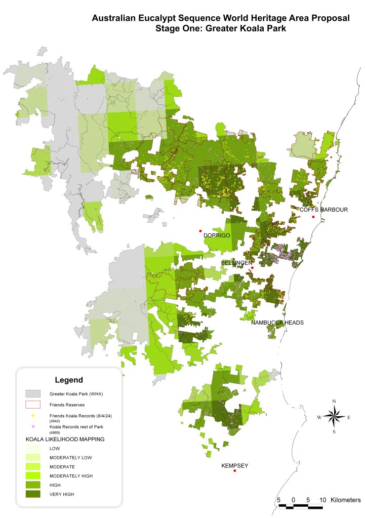
This data has been generated using a sub-set of the NSW koala data, relevant to the proposal footprint. It is not the government’s ‘likelihood’ map, which covers the whole of NSW, but a map based on the koalas records in the proposal (some 5,000 records), using a six-point scale. The koalas most relevant to the proposal are those contained within it. There are problems associated with the government’s data, but the size of the dataset is large enough to have generated sufficiently valid data. The accuracy is still delimited to a 10km grid, but there are enough records in each grid to give a generally reliable representation of the situation.
Most importantly, it demonstrates the importance of the Friends’ Reserves for koalas (see above). Combined with the conservation values maps (discussed immediately below), it demonstrates the merits of every Friends Reserve, either from a koala likelihood, or conservation values perspective, or both – as well as the broader World Heritage Area, and the coastal hardwood plantations the Government is still excising from the park.
The significance of the Friends’ reserves is emphasised by the total number of koala records within them – more than one half of the total for the whole proposal area.
3) Land management

This map locates the individually colour-coded community-based Friends Reserves in the context of the broader WHA, exisiting parks and reserves, and state forest. This helps situate the Friends Reserves within the broader nomination. There are inevitably some quirks in the legends, etc., and this will all be dealt with in due course. These images are not geo-referenced, but are of a sufficient resolution to be printed at A0. Copies available on request. All information used is publicly available NSW Government data, and/or provided on request by the relevant agencies.
This work is being shared with all relevant stakeholders to help bolster the prospects of World Heritage status for our wonderful forests, and koalas.
Briefings are available on request, and updates on activities will be posted.
4) Status of ongoing logging within the proposed World Heritage Area (13/11/2023)

